The Geospatial Medallion Architecture
A five-stage architecture that extends bronze, silver, and gold to cover geospatial acquisition and application serving.
Publication contents
Add acquisition and serving to the medallion.
Bronze, silver, and gold remain useful. Geospatial systems add meaningful work before bronze and after gold, and they require a broader definition of analysis-ready data in silver.
Source data may need catalog discovery, licensing, tasking, and bulk transfer before it can be preserved. A finished product may need tiles, low-latency lookups, extracts, or governed shares before a consumer can use it. Acquisition and serving therefore have their own ownership, cost, and quality requirements.
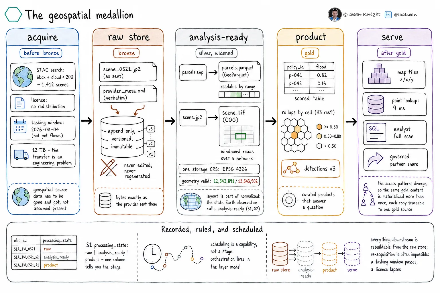
The five stages
Acquire
Find, order, license, and retrieve source data. Discovery, tasking, and transfer are visible parts of the pipeline.
Before bronzeRaw store
Keep source bytes and provider metadata exactly as received in a versioned, immutable source of truth.
BronzeAnalysis-ready
Validate, normalize, and convert data into cloud-native physical layouts with explicit geometry and metadata.
SilverProduct
Publish curated outputs that answer a question: enriched features, scored assets, aggregates, indexes, and model results.
GoldServe
Deliver products through analytical queries, tiles, low-latency lookups, model endpoints, applications, and governed shares.
After gold1. Acquire
Discover, license, task, receive, or transfer data from a provider. Record source identity, collection time, license and redistribution constraints, expected volume, transfer method, and delivery completeness before downstream processing begins.
2. Raw store as bronze
Preserve the source faithfully and append-only. Store provider metadata and checksums with the source. Corrections create new records rather than silently replacing evidence used by an earlier result.
3. Analysis-ready as silver
Validate geometry and metadata, normalize coordinate reference systems where required, and arrange data for remote and distributed access. Physical layout is part of readiness: partitioning, tiling, indexing, and cloud-native formats determine whether valid data can be used efficiently.
4. Product as gold
Create an output with explicit business meaning, quality criteria, ownership, lineage, and a defined consumer. Gold may be a feature table, exposure measure, change record, prediction, or other governed assertion rather than a visual map.
5. Serve
Derive representations optimized for consumer access. A map client wants tiles, an application wants a low-latency lookup, an analyst wants a scan, and a partner wants a governed share. Several serving surfaces may represent one gold product.
Test each stage boundary.
Acquire to bronze: possession is complete.
The expected source arrived, its identity and integrity are recorded, and its license permits the intended retention and use.
Bronze to silver: analysis assumptions are explicit.
Geometry, coordinates, metadata, quality, and physical layout satisfy documented acceptance criteria for the intended analysis.
Silver to gold: business meaning is governed.
The output asserts something defined, has an owner and consumer, and records the inputs, code, model, and quality checks that produced it.
Gold to serve: access is fit for purpose.
The serving representation meets its consumer’s latency, scale, security, freshness, and format requirements without becoming an ungoverned source of truth.
Record lifecycle state in the catalog.
Catalog metadata should state a dataset’s lifecycle stage and guarantees. Folder names are insufficient for governance and discovery.
Every governed representation should record its lifecycle stage, steward, source lineage, creation process, quality checks, update cadence, coordinate reference system, spatial and temporal extent, and applicable license constraints. Derived products should also identify the business assertion they make and the consumer they support.
Several stages can coexist.
The raw source remains available while silver and gold representations evolve. A new preparation method can create a new silver representation without erasing prior products. Lineage connects each product and serving surface to the exact representation and process used to create it.
Begin with one path from source to decision.
- 1.
Choose one governed product.
Select an output tied to a consumer and business decision, with a bounded set of spatial sources.
- 2.
Inventory every current representation.
Label what is acquired, faithfully preserved, analysis-ready, productized, and served. Do not use one label for several guarantees.
- 3.
Define boundary tests.
Write acceptance criteria for integrity, analysis readiness, product meaning, and serving fitness.
- 4.
Prove reproducibility.
Rebuild a downstream representation from bronze and verify that lineage identifies the source and transformation.
See more LakeGeo in your Google Search and AI results.
Make LakeGeo a preferred source on GoogleFrequently asked questions
What is the Geospatial Medallion Architecture?
It is a five-stage data lifecycle for geospatial systems: acquire, raw store as bronze, analysis-ready as silver, product as gold, and serve. It extends the familiar three-stage medallion model to include provider acquisition and consumer-specific serving.
Why is acquisition outside bronze?
Geospatial data often must be discovered in provider catalogs, licensed, tasked before collection, or transferred at large scale. Those decisions occur before the organization possesses a durable source copy, so they need their own designed stage.
Why does silver include physical layout?
A spatial file can be logically valid and still perform poorly in cloud and distributed systems. Analysis-ready geospatial data includes suitable tiling, partitioning, indexing, coordinate normalization, and formats such as GeoParquet or Cloud Optimized GeoTIFF.
Why is serving a separate stage after gold?
A governed product can have several consumers with incompatible access patterns. Maps may need tiles, applications may need low-latency lookups, analysts may need scans, and partners may need governed shares. Serving derives those representations without changing the product’s business meaning.
Must every pipeline use the bronze, silver, and gold names?
No. Teams may use other labels if they preserve the distinctions between faithful source retention, analysis-ready preparation, governed products, and consumer-specific serving. The guarantees matter more than the color names.
Can downstream data be deleted and rebuilt?
Yes, when the raw store and transformation definitions are complete. Every stage downstream of bronze should be reproducible. Operational backups may still be required, but derived data should not be the only record of an irreversible transformation.
- Identifier
- LGP-ARC-001
- Version
- 0.1, public draft
- Published
- License
- CC BY-SA 4.0
Suggested citation: LakeGeo, The Geospatial Medallion Architecture, v0.1, public draft, 2026, https://lakegeo.ai/architecture/medallion/.
Release history
First public draft of the five-stage architecture, stage boundary tests, metadata guidance, and adoption sequence.