How to Build a Geospatial Lakehouse on Google Cloud
A service-by-service architecture for governed vector, raster, machine learning, and application workloads on Google Cloud.
Publication contents
Platform guides
On this page
Google Cloud as the governed geospatial platform
Google Cloud implements the stack across several managed services. BigQuery is the vector SQL and analytical center. Cloud Storage and BigLake hold open-format data. Earth Engine provides managed raster analytics. Dataproc and Dataflow handle custom distributed processing.
This composition provides the strongest managed raster option of the three platform guides. It also creates more service boundaries. Governance, identity, lineage, orchestration, and cost controls must cover BigQuery, Cloud Storage, Earth Engine, Dataproc or Dataflow, Composer, and Vertex AI.
Technical foundation
- Native GEOGRAPHY and spatial SQL in BigQuery, with native S2 functions for grid-prefiltered joins.
- Earth Engine in BigQuery for managed zonal statistics over Earth Engine data and registered imagery.
- Dataproc or Dataflow for raster products and distributed processing that Earth Engine does not provide.
Does Google Cloud have native raster support?
Google Cloud provides managed raster analytics through Earth Engine and custom raster processing through Dataproc or Dataflow. Earth Engine has its own asset model and does not replace every file-based raster production workflow.
The Geospatial Lakehouse Stack on Google Cloud
Six layers connect source acquisition to governed data products and the applications that use them.
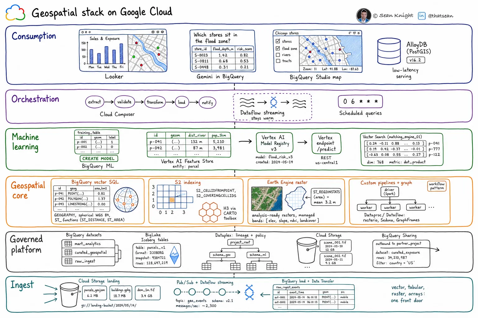
Ingestion
Cloud Storage for file landing, BigQuery Data Transfer Service and load jobs for batch, Pub/Sub with Dataflow for streams, and Storage Transfer Service for provider archives.
Storage and governance
BigQuery tables for vector data, BigLake managed Iceberg tables where open formats matter, Cloud Storage for files, Dataplex Universal Catalog for governance, and BigQuery Sharing for distribution.
Spatial compute
BigQuery spatial SQL and S2, Earth Engine for managed raster analysis, Dataproc or Dataflow for custom raster pipelines, and GraphFrames on Dataproc for graph workloads.
Machine learning and AI
BigQuery ML for in-warehouse models, Vertex AI for custom training and serving, Vertex AI Vector Search, and Gemini in BigQuery.
Orchestration
Cloud Composer for cross-service pipelines, Dataflow for continuous processing, and scheduled queries or Workflows for simpler jobs.
Consumption
Looker and Looker Studio, BigQuery geospatial visualization, Cloud Run with Maps Platform, and AlloyDB or Cloud SQL with PostGIS for low-latency serving.
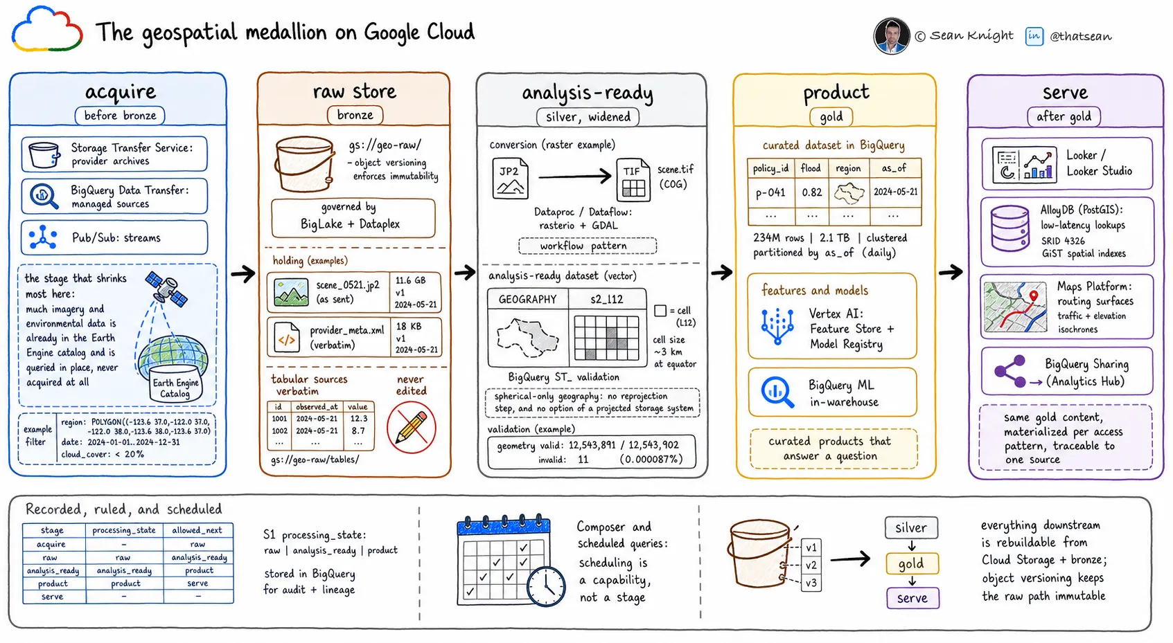
The geospatial medallion on Google Cloud
Each lifecycle stage has a specific storage, processing, governance, and serving responsibility.
| Stage | Platform implementation |
|---|---|
| 01 Acquire | Use Storage Transfer Service for archives, BigQuery Data Transfer Service for managed sources, and Pub/Sub for streams. Query Earth Engine catalog data in place when acquisition would create an unnecessary copy. |
| 02 Raw store Bronze | Keep source files in versioned Cloud Storage buckets governed through BigLake and Dataplex. Preserve tabular sources in bronze BigQuery tables. |
| 03 Analysis-ready Silver | Use Dataproc or Dataflow for cloud-optimized raster conversion. Validate vectors in BigQuery and add S2 indexes. Use Earth Engine assets directly when its catalog and processing model meet the requirement. |
| 04 Product Gold | Publish governed BigQuery datasets with defined business meaning. Register custom features and models through Vertex AI where required. |
| 05 Serve | Use Looker for analysis, AlloyDB or Cloud SQL with PostGIS for application lookups, Maps Platform for routing and maps, and BigQuery Sharing for partners. |
Strengths and constraints
Strengths
- Earth Engine provides managed raster analysis and access to a large catalog of analysis-ready environmental data.
- BigQuery provides serverless vector SQL with native S2 indexing.
- Maps Platform supplies managed routing and map services.
- AlloyDB and Cloud SQL provide PostGIS-compatible application-serving options inside Google Cloud.
Constraints
- The stack spans more services and operational boundaries than the Databricks or Snowflake designs.
- BigQuery provides spherical GEOGRAPHY without a planar GEOMETRY type. Projected-coordinate workflows require adaptation or another engine.
- S2 is native. H3 compatibility depends on an extension such as the CARTO Analytics Toolbox.
- Earth Engine has its own asset model, quotas, and catalog semantics.
- Graph processing and custom raster production require Dataproc, Dataflow, or another engine.
See more LakeGeo in your Google Search and AI results.
Make LakeGeo a preferred source on GoogleFrequently asked questions
Can Google Cloud run a complete geospatial platform?
Google Cloud can provide the governed center for a production geospatial system. Some workload classes use native services, while others require operated workflows or specialist engines. The stack on this page identifies those boundaries.
Does this architecture eliminate specialist geospatial tools?
No. Specialist tools remain appropriate for capabilities the platform does not supply, including some raster, point-cloud, topology, graph, and routing workloads. They should read and write governed data with clear operational ownership.
Where should implementation begin?
Begin with one governed product tied to a consumer and decision. Map its sources, transformations, quality gates, and serving requirements across the six stack layers and five lifecycle stages before selecting additional services.
- Identifier
- LGP-PLT-003
- Version
- 0.1, public draft
- Published
- License
- CC BY-SA 4.0
Suggested citation: LakeGeo, How to Build a Geospatial Lakehouse on Google Cloud, v0.1, public draft, 2026, https://lakegeo.ai/architecture/google-cloud/.
Release history
First public draft covering platform fit, the six-layer stack, the geospatial medallion, strengths, and constraints.