How to Build a Geospatial Lakehouse on Databricks
A service-by-service architecture for governed vector, raster, machine learning, and application workloads on Databricks.
Publication contents
Platform guides
On this page
Databricks as the governed geospatial platform
Databricks can run geospatial work in the same catalog, tables, compute, orchestration, and access-control system used for other production data. Native spatial SQL and H3 cover the core vector workloads. Raster and point-cloud processing remain operated workflows over governed files.
This architecture replaces separate PostGIS servers, desktop geographic information system handoffs, and contractor-operated imagery pipelines when those systems duplicate governance or prevent spatial results from joining cleanly to business data. Specialist engines can remain where they provide a capability Databricks does not.
Technical foundation
- Native GEOMETRY and GEOGRAPHY columns in Delta tables, with the ST_ function family and optimized spatial joins.
- Native H3 functions for cell assignment, coverage, neighborhood operations, hierarchy, and grid-prefiltered joins.
- Parallel Python processing with rasterio and GDAL over files in Unity Catalog volumes, with Delta tables carrying raster metadata and lineage.
Does Databricks have native raster support?
Databricks has no native raster type. Raster processing runs through governed files and distributed Python or container workflows, with metadata and outputs stored in the platform’s cataloged data layer.
The Geospatial Lakehouse Stack on Databricks
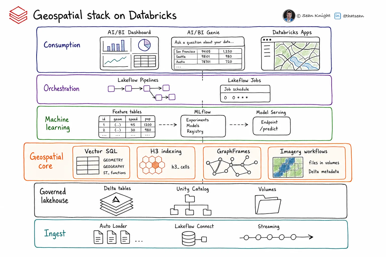
Six layers connect source acquisition to governed data products and the applications that use them.
Ingestion
Auto Loader for arriving files, Lakeflow Connect for managed sources, and Structured Streaming for live feeds.
Storage and governance
Delta tables with native spatial columns; Unity Catalog for discovery, lineage, and access control; volumes for raster and point-cloud files; Delta Sharing and Marketplace for distribution.
Spatial compute
Native spatial SQL and H3; GraphFrames for graph analytics; rasterio and GDAL in distributed Python workflows for raster processing.
Machine learning and AI
Feature Engineering in Unity Catalog, MLflow and Models in Unity Catalog, Mosaic AI Model Serving, and Databricks Vector Search.
Orchestration
Lakeflow Declarative Pipelines for managed transformations and Lakeflow Jobs for scheduling, dependencies, retries, and operational control.
Consumption
AI/BI Dashboards and Genie for analysis, Databricks Apps for custom interfaces, Lakebase for low-latency application serving, and Delta Sharing for partners.
The geospatial medallion on Databricks
Each lifecycle stage has a specific storage, processing, governance, and serving responsibility.
| Stage | Platform implementation |
|---|---|
| 01 Acquire | Use Lakeflow Connect for managed sources, Auto Loader for delivered files, and notebooks or jobs for provider catalogs and ordering APIs. |
| 02 Raw store Bronze | Keep source files in write-once Unity Catalog volume paths. Preserve tabular sources in bronze Delta tables without correcting source values in place. |
| 03 Analysis-ready Silver | Convert raster files to cloud-optimized layouts with rasterio and GDAL. Validate and transform vector geometry, then add the spatial indexes required by downstream joins. |
| 04 Product Gold | Publish governed Delta tables with defined business meaning. Register reusable features and models in Unity Catalog. |
| 05 Serve | Use dashboards and Genie for analysis, Apps and Lakebase for applications, and Delta Sharing or Marketplace for external distribution. |

Strengths and constraints
Strengths
- Spatial SQL, H3, graph processing, and distributed raster workflows can run on the same compute platform.
- Unity Catalog governs spatial tables and raster files together.
- Optimized spatial joins and native H3 support large vector enrichment workloads without a separate spatial database.
- The machine learning and application layers use the same governed data products produced by the spatial pipelines.
Constraints
- Databricks has no native raster, point-cloud, topology, or weighted-routing type. Teams must build and operate those workflows.
- Long-distance calculations require deliberate use of GEOMETRY or GEOGRAPHY according to the coordinate model and function support.
- Large raster and machine learning jobs need workload-specific cost and performance testing.
- Applications may still require a dedicated low-latency serving store even when Delta tables remain the governed source.
See more LakeGeo in your Google Search and AI results.
Make LakeGeo a preferred source on GoogleFrequently asked questions
Can Databricks run a complete geospatial platform?
Databricks can provide the governed center for a production geospatial system. Some workload classes use native services, while others require operated workflows or specialist engines. The stack on this page identifies those boundaries.
Does this architecture eliminate specialist geospatial tools?
No. Specialist tools remain appropriate for capabilities the platform does not supply, including some raster, point-cloud, topology, graph, and routing workloads. They should read and write governed data with clear operational ownership.
Where should implementation begin?
Begin with one governed product tied to a consumer and decision. Map its sources, transformations, quality gates, and serving requirements across the six stack layers and five lifecycle stages before selecting additional services.
- Identifier
- LGP-PLT-001
- Version
- 0.1, public draft
- Published
- License
- CC BY-SA 4.0
Suggested citation: LakeGeo, How to Build a Geospatial Lakehouse on Databricks, v0.1, public draft, 2026, https://lakegeo.ai/architecture/databricks/.
Release history
First public draft covering platform fit, the six-layer stack, the geospatial medallion, strengths, and constraints.